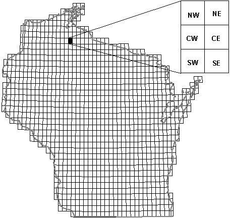
Each 7.5 minute USGS topographic quadrangle in Wisconsin was divided into six
blocks - NW, NE, CW, CE, SW, SE - each of size 5km x 5km (10 sq mi). Within a
given block, atlasers recorded each bird species detected, breeding code of the
species, observation date, and optionally, habitat code and abundance code. Due
to time constraints, it was not possible for atlasers to survey every block within
a given quad, thus the centereast (CE) block was designated the Priority Block.
In order for the Atlas to be complete, the Priority Block was surveyed for each
quad. Additionally, there are 138 quads which contain one or more Specialty Blocks
for which habitat information of each species observation was required.
Atlasers completed a new field card for every block they surveyed. The atlaser
recorded the year, quad name, and block. A record of field visits was kept containing
date of each survey trip, whether the trip was a night survey, number of hours
spent in the field each trip, total number of observers on each trip, total number
of hours spent traveling to and from field sites, and total mileage. Additionally,
atlasers completed casual observation forms to record species in blocks the atlaser
was not formally surveying.
| |