
|
||||||||||||
| Goals | Methods | Survey Sites | Enter Data | Query Data | Contact Us | Links | ||||||
Teal Flowage, Mead Wildlife Area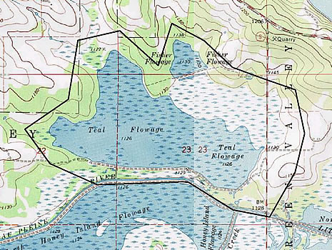 Site Directions: See page 64 of Wisconsin Atlas and Gazetteer. From I-39 take the Hwy 34 exit (between the cities of Stevens Point and Wausau). Go west on Hwy 34 for 4.5 miles to CTH C. Travel south on CTH S for 1.5 miles. Site Description: This flowage parallels the Little Eau Pleine River within the George W. Mead State Wildlife Area in north-central Wisconsin. Visibility and site stability will depend on water levels. Shorebird surveys will take 1-2 hours. During 2002, Teal Flowage will not be drawn down, limiting available shorebird habitat. Current Coverage: Volunteers needed. Sampling Periods: APR 29 to MAY 30, AUG 15 to SEP 30. Survey Protocol: Survey areas from road only; survey those areas providing shallow water and mudflats. Due to lack of draw down in 2002, shorebird presence is problematic; therefore, the plot (observation point) is variable. If shorebird observations occur, indicate with an "X" on Map above where viewing occurred. Reocrd all species and number observed during 1-3 10-minute observation periods per plot. If more than one observation period occurs, indicate each observation period separately. Species and Peak Numbers: 20+ species have been observed including White-rumped Sandpiper, both godwits, both dowitchers, Stilt Sandpiper, and Wilson’s Phalarope. Local Contact: Tom Meier (715) 457-6771 / meiert@dnr.state.wi.us. |