
|
||||||||||||
| Goals | Methods | Survey Sites | Enter Data | Query Data | Contact Us | Links | ||||||
Theresa Wildlife Area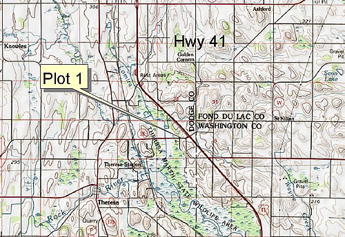 Site Directions: See page 46 of Wisconsin Atlas and Gazetteer. Theresa Marsh lies west of Hwy 41 and east of Hwy 175. Hwy 28 crosses the northern portion of the marsh providing the best viewing opportunities. Plot #1 (the only plot) lies along the north side of Highway 28 and is approximately 0.33 miles west of State Highway 41 (see maps). Site Description: Theresa Marsh is located in eastern Dodge and western Washington counties in southeastern Wisconsin. Impoundments along State Highway 28 provide periodic shorebird habitat as water levels on these sites are drawn down for waterfowl habitat management. There are 1-3 impoundments that could be suitable for observation depending on habitat conditions. Stability of these sites is fair and dependent on water level management. Visibility of shorebirds can be good (>80%) from the roadside. Shorebird surveys will take 1-2 hours. Longitude: -88.4217 Current Coverage: Volunteers needed. Sampling Periods: APR 30 to MAY 30, AUG 15 to SEP 30. Survey Protocol : No surveys are being conducted during spring 2003, due to high water levels. Species and Peak Numbers: Common to fairly common species observed include: Semipalmated Plover, Killdeer, Greater Yellowlegs, Lesser Yellowlegs, Solitary Sandpiper, Spotted Sandpiper, Semipalmated Sandpiper, Least Sandpiper, Pectoral Sandpiper, Stilt Sandpiper, Short-billed Dowitcher, Common Snipe, and Wilson’s Phalarope. Uncommon species sighted on this property include Willet, Hudsonian Godwit, White-rumped Sandpiper, and Long-billed Dowitcher. Local Contact: Bill Volkert (920) 387-7877 / volkew@dnr.state.wi.us. |