| Dec 31 |
 |
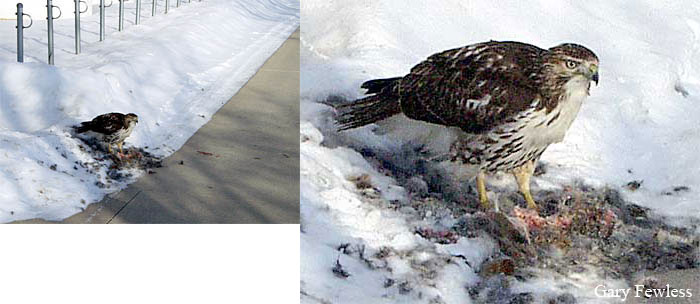
The photo at left is of a Red-tailed Hawk at a suet feeder. This is normally a bird that hunts for a living, but perhaps the very cold weather convinced this one to go for the easily accessible and high calorie suet. Photo by Tom Erdman (Dec. 28) who says there were many birds in the area that are normally prey species for Red-tailed Hawks, but they were completely ignored here in favor of the suet. We can expect to see unusual behavior when conditions are extreme.
Check out the Red-tailed Hawk eating a cottontail on the sidewalk immediately next to a classroom building at UWGB on January 2, 2001, from our phenology archives. You can search the phenology archives at upper left. |
|
| Dec 30 |
 |
A cold morning as Green Bay reports -19° F at about 7:00 a.m., our coldest temperature so far this winter and a record low for this date. The daily high temperature was 0° F, the lowest high temperature of the winter, making this clearly the coldest day to date.
A temperature of -26° F reported at Rhinelander about 100 miles NW.
The photos is of Mahon Creek in UW-Green Bay's Cofrin Arboretum, on this very cold morning. It was about -10° when the photo below was taken. The creek is frozen here, the ice thin and clear and probably only formed overnight. Baird Creek is also mostly frozen now. |
|
| Dec 29 |
Low temperature of -5° F. |
| Dec 28 |
High temperature of 38° seems almost spring-like, but tonights low is predicted to fall below zero again as cold arctic air descends from Canada. The above-freezing period lasted for about 6-7 hours. |
| Dec 27 |
Green Bay's high temperature of 33° F is the first time above freezing since Dec. 5, albeit only for an hour or so. |
| Dec 26 |
Standing snow depth was 15 inches. |
| Dec 25 |
Green Bay received 3.2 inches of snow today for a total of 26.2 inches this month. |
| Dec 24 |
| |
Green Bay's low temperature was -14° F, the lowest of the season. The high temperature was only +9°. |
 |
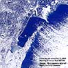
Green Bay is almost completely frozen over. Photo from NOAA Coastwatch program's MODIS photos. Compare to photo of Dec 11. |
|
| Dec 23 |
 |
Two deer on the Cofrin Arboretum at UW-Green Bay this morning. this is already becoming a difficult winter for them with unseasonably early cold and deeper snow. Today's standing snow depth is 12". |
 |
Northern pin oak (Quercus ellipsoidalis) with many dead leaves still attached, as is commonly the case. |
|
| Dec 22 |
Green Bay received 6 inches of snow, a new record for this date (the old record was 4.7 inches in 1942). Areas along the Lake Michigan shore and farther south had even more snow. |
| Dec 21 |
Green Bay has not been above freezing since Dec 5 (16 days).
There are still more Robins around than I would expect considering the early and strong winter to date. There are always a few hanging around where there are dependable bird feeders, but I'm seeing them even out in the woods locally, 8-10 together. |
| Dec 18 |
 |
The mouth of the Fox River at Green Bay is totally ice-covered now except for the path created by the Coast Guard ice-breaker, a small area of discharge from the Pulliam power plant and the discharge from Green Bay Metro sewerage facility (near side of river, not visible behind the retaining wall). |
|
Among the many Mallards and Canada Geese, there were a few Common Mergansers and a single Double-crested Cormorant at the Fox River Mouth this morning. Also 5 immature Bald Eagles on the ice. |
|
| Dec 17 |
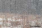 |
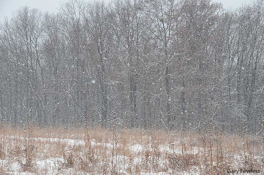
Green Bay's temperature was about 11° F at sunset yesterday and rose slowly throughout the night to 14° by sunrise and 24° by 10:00 a.m. The high temperature reached 32° F, but just barely and for less than an hour in the afternoon. Light snow began to fall about 5:00 a.m. and continues to mid-day. Photo in the prairie at UWGB. |
 |
New snow on Mahon Creek in UW-Green Bay's Cofrin Arboretum. |
|
| Dec 16 |
Green Bay's morning low temperature was -13° F, our lowest of the winter to date. Our highest temperature in about the last 10 days was 22° F. |
| Dec 15 |
Low temperature of -5° F in Green Bay. |
| Dec 14 |
Snow beginning yesterday and ending about 2:00 p.m. today totaled 3.2 inches for the 2 days. |
| Dec 13 |
 |
The recent period of unusually cold weather has dramatically increased the ice-cover on Green Bay (see Dec. 11) and the Fox River. This reduces the area of open water and tends to increase the density of the wintering waterfowl where the water remains open. The photo at left is a Common Merganser, seen among many others this morning. |
|
| Dec 12 |
 |
Low temperature of -3° F in Green Bay, and about 80 miles NNW in Laona, the low was -12 F.
Baird Creek is completely ice-covered, as near as I can tell without walking the entire length. This photo is of the well-known "falls" just west of Baird Creek Road, and it is usually among the last locations to become ice-covered. |
|
| Dec 11 |
 |
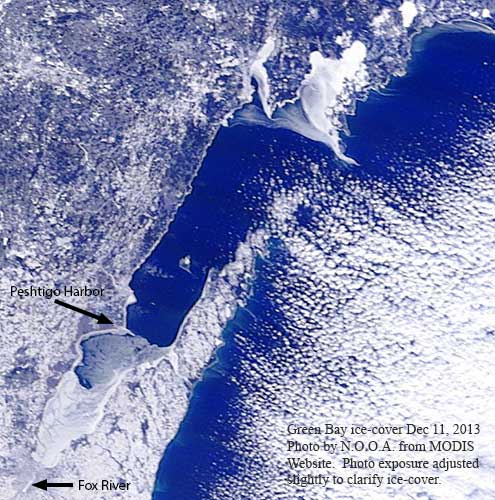
The Bay was mostly ice-free except for very near shore on Dec 5, but by Dec. 11 the lower bay was ice-covered from the mouth of the Fox River north to a line from about Pensaukee to Little Sturgeon Bay, with floating ice north to Peshtigo Harbor. If you look closely at the lower left in the photo, you can also see that the Fox River is ice-covered south to the DePere dam (except for right at the river's mouth). |
Green Bay's low temperature was -6° F. The high temperature was 9° F, and it occurred before sunrise, with temperatures falling thereafter until about 9:00 a.m. and rising only to 5° in the afternoon. Wind chills -15 to -20 most of the day.
Green Bay has been below freezing continuously for about 6 days and really the highest temperature in that period was 17°. The daily temperatures have been between 15°to 19° below the "normals" (21 degrees lower today). The forecast is to remain well below freezing for the next 10 days (keeping in mind the low success of 10-day forecasts). |
|
|
| Dec 10 |
| Green Bay's low temperature of -5° F is yet again a new low for the season [looks like 13° will be today's high]. Over the last several days a large winter storm swept across the U.S.A. with snow, dangerous roads and thousands of cancelled flights, followed by the movement of cold arctic air across the northern regions. The northeast is getting mostly rain today as the storm moves out toward the Atlantic, and it's cold, clear and windy in Wisconsin with wind chills below zero in double digits. |
|
|
| Dec 9 |
 |
A cold weekend, and snow Sunday afternoon and night, brought a very winter-like look to the landscape--seen here from UW-Green Bay's shoreline looking about northwest. Today's low temperature is now the lowest of the season at -3° F. An additional 1.0 inch of snow today brought the two day storm total to 3.2 inches. |
|
| Dec 8 |
Green Bay received 2.2 inches of snow. |
| Dec 7 |
| Green Bay's low temperature of -1° F is the lowest of the season to date, and about 17 degrees below the "normal" low for today. Last year's low on this date was +32° F. Just for the record, "normal" as used in the local reports refers to the average low over a recent 30 year interval. The daily high temperature was 11°, which is also the lowest daily high temperature of the season. |
|
|
| Dec 5 |
 |
The snow of Dec. 3 is mostly gone after yesterday's warm temperatures (high of 45° F). The temperature is down to about 20° F today with winds in mid to upper twenties and gusts to 37 mph. |
|
| Dec 4 |
| Wisconsin DNR has released preliminary figures for the recent gun deer season. The number of deer registered is 226,582, which is about 7% below last year's report. The density of deer is apparently highly variable from one area to another within the state. |
|
|
| Dec 3 |
 |
Light snow began about 2:00 a.m., and continued lightly throughout the morning in Green Bay. [the daily total was 3.9 inches, gf] |
|
| Dec 2 |
 |
December begins with little snow, and ice-covered ponds, but warmer than average temperatures (upper thirties for highs). |
|


