Phosphorus Removal Research
Pond-Wetland Systems & Phosphorus Removal Field Research Site
Pond-Wetland Systems (PWS) are engineered edge-of-field practices that slow runoff, settle sediment and support downstream water-quality goals—while generating monitoring data needed for watershed decision-making and water quality trading. Long-term monitoring at our northeastern Wisconsin research site shows strong reductions in suspended sediment and total phosphorus, with lower dissolved phosphorus reductions that motivate Phosphorus Removal System (PRS) add-ons and upgrades. The PWS and PRS Research Site provides valuable hands-on research experience for high school, undergraduate and graduate students seeking degrees related to Water Science, Environmental Engineering, Environmental Science, Biology and Chemistry.
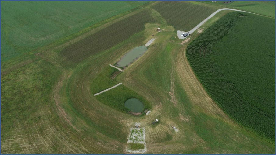
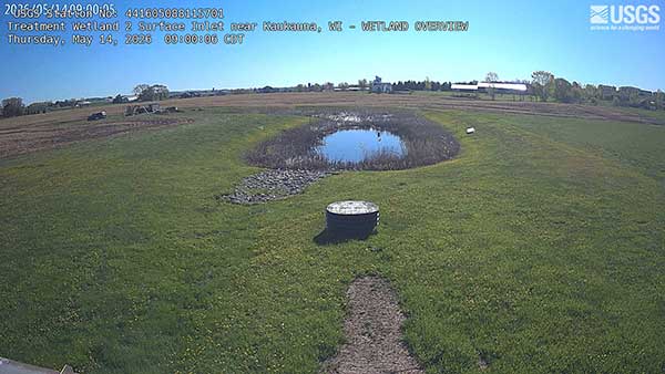
Aerial view of the research site surface inlet near Kaukauna, WI
Photo by Wes Kotila, Outagamie County Land Conservation
Location in lower Fox River basin, near Kaukauna, WI
USGS-441605088115701
How the System Works
(PWS → PRS Treatment Train)
A Pond–Wetland Systems (PWS) treatment train typically combines multiple accepted conservation-practice elements into one system: runoff and tile drainage enter a sediment forebay/basin, flow through treatment wetland cells and pass a water control structure that meters discharge. A Phosphorus Removal System (PRS) can be added downstream to target dissolved phosphorus using reactive filter media and controlled discharge.
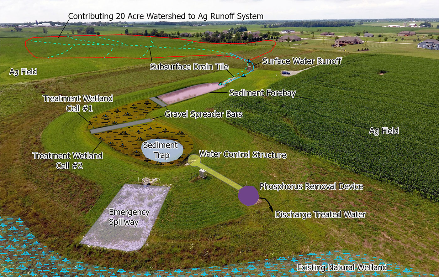
Photo by Wes Kotila, Outagamie County Land Conservation
Phosphorus Removal System (PRS)
See the phosphorus removal of each tank at the USGS monitoring site page.
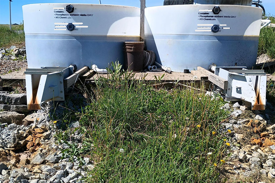
Front of a Phosphorus Removal System
Photo by Beth Kondro
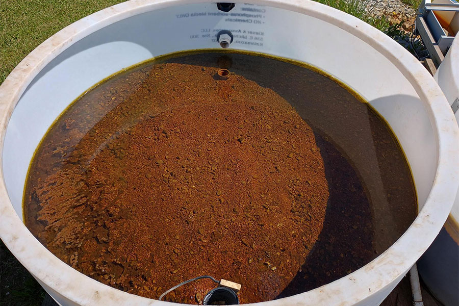
Inside of a Phosphorus Removal System
Photo by Beth Kondro
Performance Highlights
Six years of year-round monitoring at the NRCS-standard pond–wetland system treating runoff and tile drainage from an 8.5‑ha mixed agricultural/residential basin shows strong reductions in suspended sediment (44–72%) and total phosphorus (21–48%) and ~86% peak-flow attenuation, with lower dissolved phosphorus reductions (9–27%) that motivate PRS integration and other upgrades.
Water Quality Trading Relevance
Pond–Wetland Systems (PWS) and Phosphorus Removal Structures (PRS) can support water quality trading by providing replicated practice design elements and transparent monitoring data that help quantify reductions and document performance over time. Trading programs often rely on credible monitoring and clear practice documentation; this site is designed to help provide both.
Real-Time Imagery & Monitoring Charts
Live site cameras and monitoring charts are available on the United States Geological Survey (USGS) site for each testing station. USGS imagery may be provisional; refer to official USGS pages for data status. Live monitoring of phosphorus removal and flow from two filter media tanks. Operating multiple tanks at the same time allows for testing and comparing different filter media materials to determine which options provide the most efficient phosphorus removal. Currently, the filter media tanks contain different amounts of zero-valent iron. Future enhancements at the site will include monitoring of a roll-off dumpster filter media system. Data collected from this system will be used to evaluate system performance and support the development of a mobile PRS that can be deployed in high-risk areas to reduce phosphorus loading and improve water quality.
Real-Time Imagery & Monitoring Charts
Live site cameras and monitoring charts are available on the United States Geological Survey (USGS) site for each testing station. USGS imagery may be provisional; refer to official USGS pages for data status. Live monitoring of phosphorus removal and flow from two filter media tanks. Operating multiple tanks at the same time allows for testing and comparing different filter media materials to determine which options provide the most efficient phosphorus removal. Currently, the filter media tanks contain different amounts of zero-valent iron. Future enhancements at the site will include monitoring of a roll-off dumpster filter media system. Data collected from this system will be used to evaluate system performance and support the development of a mobile PRS that can be deployed in high-risk areas to reduce phosphorus loading and improve water quality. See the phosphorus removal of each tank at the USGS monitoring site page.
Publications & Media
Background articles and information related to the Pond–Wetland Systems (PWS) and Phosphorus Removal research.
- Article: Constructed stormwater pond and wetland for agricultural runoff treatment
by Michael A. Holly, Kevin Fermanich, Jeremy Freund, Andrew Votis,
ScienceDirect, Agriculture, Ecosystems & Environment, Volume 403, 2026 - Video: Agriculture Runoff Treatment Systems (ARTS) in Wisconsin
The Nature Conervancy YouTube, Nov 12, 2024, 6 min. 59 sec. - Article: Ag Runoff Treatment Systems: A New(er) Practice in the Conservation Toolbox
by Katie Woodrow, Aug. 31, 2022, Fox-Wolf Watershed Alliance
Collaboration Partners
The Pond–Wetland Systems (PWS) and Phosphorus Removal Structures (PRS) Field Research project is made possible with our collaboration partners.


Have Questions?
Questions about the field site, monitoring or replication? Contact Michael Holly, Associate Professor of Environmental Engineering at hollym@uwgb.edu.